Chapter 3
The problems facing the Coorong and Lower Lakes
3.1
The Coorong and Lower Lakes system are suffering from the effects of
inadequate inflows of fresh water. The Murray-Darling Basin (the Basin) is
currently experiencing the worst drought on record, water volumes in the entire
Basin are very low and River Murray flows into the lakes are well below that
required to exceed evaporation from the lakes' surface. This has led to the
level of fresh water in the lakes falling below sea level and has halted the release
of fresh water into the Coorong North Lagoon, in turn contributing to the
closing of the Murray Mouth.
3.2
The committee notes the view of the MDBC that the general ecological
decline in the Lower Lakes and Coorong has occurred over many decades and needs
to be considered within the context of climate change and wider Basin reforms.[1]
The current drought
3.3
Submissions commented on the unprecedented nature of the current
drought. The Wentworth Group stated that two years ago the Group warned that
evidence was growing 'that this was more than just a drought' and since then
conditions have worsened:
We warned that our continent is getting hotter, that rainfall
patterns have changed significantly and it is likely that southern Australia
has experienced a steep change in its weather patterns, more reminiscent of the
pre 1950s, than the high rainfall period we experienced since.[2]
3.4
The MDBC stated that for large parts of southern and eastern Australia,
dry conditions have persisted since October 1996, but have been exacerbated in
recent years. During the last seven years in particular, the Basin has
experienced severe rainfall deficiencies. The period from September 2001 to
August 2008 was the second driest seven-year period on record (the driest was
from 1939 to 1946). This rainfall deficiency, particularly in the alpine areas,
has been the main cause for the record low inflows to the Murray system.
3.5
The current dry period and low water availability can be put into
perspective by comparisons with similar extended droughts in the early and mid-twentieth
century. The average annual Murray inflow of 3800GL/yr during the current
drought (2002 to 2008) is lower than that experienced in the previous worst two
droughts on record – 4900GL/yr in 1897 to 1904, and 5600GL/yr in 1938 to 1946.
3.6
Rainfall during this drought has been comparable to previous dry periods.
However, inflows and water availability have been considerably lower. The
current drought has also recorded the lowest inflows for virtually all periods
from one month to ten years. In particular, for the two years ending August
2008, Murray system inflows were 3540GL which is almost half the previous two
year minimum prior to this drought (of 6800GL in 1943-45).[3]
3.7
The MDBC has identified five factors that have contributed to the
severity of the current drought:
- Over allocation – the second half of the 21st century was
significantly wetter than the first half. Consistently wet weather, dam
construction between the 1950s and 1990, and the accepted wisdom that only a
percentage of new entitlements would be utilised, underpinned an expansion in
irrigation entitlements. A larger number of irrigators dependent on the resource
than previous droughts exacerbated the impact of the water shortage.
- Higher temperatures – three of the last five years, in the Basin,
have been the hottest on record (of approximately 100 years of records). Higher
temperatures increase evaporation and dry the catchment, resulting in less
runoff. The impact of higher temperatures and a drier catchment have been
clearly evident since September 2007 when a La Nina system bought above average
rainfall to most of the River Murray catchment between September 2007 and March
2008, yet inflows remained very low.
- Changed rainfall patterns – Research indicates that a significant
reduction in autumn rainfall has occurred over the MDB. Research points to a strengthening
of a ‘subtropical ridge’ of high pressure over the Basin during the autumn
months. Historically, the subtropical ridge is present in summer but weakens
and moves rapidly north during autumn, allowing frontal systems to bring rain
to the Basin (and south eastern Australia generally). Research links the persisting
southerly subtropical ridge to climate change and the effect of diverting
autumn storm systems to the south of the Basin.
- The lowest inflow year on record – total annual River Murray
system inflow during 2006-07 was 1040GL, approximately 60% below the previous
record minimum. Such an unprecedented dry year almost completely exhausted the
River Murray’s main drought storage, Dartmouth Dam. This has resulted in the
current situation of allocations being almost entirely dependent on inflows.
- Two consecutive very dry years – following 2006-07, the driest
year on record, 2007-08 has also been a very dry year. Never before, in the
historical record, has an extreme dry year, been followed by another very dry
year. Previously, the driest years on record 1902/03, 1914/15 and 1982/83 were
followed by significantly wetter years.[4]
3.8
The Bureau of Meteorology (BoM) also commented on the current long
drought across the Murray-Darling Basin noting that:
The current drought event commenced in southern parts of the
basin in late 1996 and more generally across the basin in around 2002. The El
Niño years of 1997, 2002 and 2006 were each notably dry across the basin. Since
2001 each calendar year has seen below-average Murray-Darling Basin rainfall –
a run of seven calendar years which is unprecedented in our records. During the
last seven years, averaged across the whole basin, there has been a total of
2860mm rainfall (an average of 407mm a year) which makes this seven-year period
the second-driest seven-year period since 1900, after the 1939-1946 drought
event (with a total rainfall of 2757mm, and an average of 394mm a year). If the
current drought event persists through 2009, it will likely overtake the
1930/1940s drought in terms of rainfall deficits.[5]
3.9
The BoM commented that an unusual feature about this drought is the
repeated failure of the autumn rainfalls. There have been eight below-average autumn
rainfalls in consecutive years, and 16 of the last 18 autumns have experienced
below-average rainfall. This has major consequences for runoff, and in part
explains why the runoff has been proportionally lower during this long drought
event.[6]
3.10
The BoM also stated that perhaps the most notable feature of the current
drought is the exceptionally high temperatures which have been experienced. The
year 2007 was the Basin’s warmest year on record (+1.13ºC above the 1961-1990
average); while 2005 was the second-warmest year on record, and 2006 the
fourth-warmest year. As a whole, this long drought has been 1 to 1.5ºC warmer
than the 1930-1940s drought. The BoM stated that this difference is the local
reflection of the global warming trend, which is substantially driven by the
enhanced greenhouse effect. Australia and the Murray-Darling Basin have warmed
by about 1ºC since the 1950s.[7]
3.11
Mr Don Blackmore gave evidence of a low ratio of average run off to
rainfall in the Basin and emphasised the relationship between rainfall and run
off is not linear. His evidence suggested that runoff is likely to be reduced
at a much faster rate than any concurrent reduction in rainfall. Furthermore:
As we know, a 10 per cent reduction in runoff does not relate to
a 10 per cent change in the flow to South Australia—it is a 20 or 30 per cent
change because of the cumulative effect.[8]
The pace of water reform
3.12
As a result of a range of initiatives flowing from the COAG water reform
framework, states and territories have made considerable progress towards more
efficient and sustainable water management. Through the National Water
Initiative (NWI) a range of planning, policies and legal and institutional
frameworks have been developed, providing the platform for the on-ground
delivery of reform.
3.13
Significant action is still required to address overallocation, improve
environmental management of water, and develop efficient water markets and
trading mechanisms.[9]
3.14
In its March 2008 report to COAG, the Working Group on Climate Change
and Water noted that:
... while significant action is being taken by jurisdictions, in
the face of a drying climate and rising demand, significant challenges remain.
For example, current best estimates indicate the [Murray-Darling Basin] is
expected to experience a fall in annual stream flow of 10-25% by 2050, with
projections of up to 48 per cent by 2100. Moreover, in the absence of increased
regulation, new estimates are that in the MDB alone, within 20 years a further
1200-3400 gigalitres of water will be intercepted annually by activities that
currently do not require a water access entitlement, such as farm dams and
bores and plantation forestry.[10]
3.15
COAG has since signed an Intergovernmental Agreement (IGA) on Murray‑Darling
Basin Reform. Under the IGA, governments commit to a new culture and practice
of Basin-wide management and planning, through new structures and partnerships.[11]
COAG has also initiated work to coordinate efforts in purchasing water for the
environment, and enhance the effectiveness of water markets. COAG has also
commissioned the development of a comprehensive new work program of water
reform to address overallocation and improve environmental outcomes, including
actions to address overallocation and improve environmental outcomes.[12]
3.16
As noted in chapter 2, under the Water Act 2007 the new
Murray-Darling Basin Authority is charged with preparing a Basin Plan for the
integrated and sustainable management of water resources in the Basin. The
Basin Plan is expected to play an important role in identifying
responsibilities for managing risks associated with reductions in water
availability and changes in reliability. A key element of that plan will be the
introduction of sustainable and integrated diversion limits on groundwater and
surface water extraction. The Basin Plan will be prepared in consultation with
Basin states and communities and is expected to be in place in 2011.[13]
3.17
Notwithstanding these initiatives, concerns remain that the pace of
water reform in the Basin in particular is not adequate to address issues such
as those currently faced by the Lower Lakes and Coorong.
Impact on the Lower Lakes and Coorong
3.18
The overall impact of the current drought and water extraction for
consumptive use has been a dramatic fall in the level of fresh water in the lakes.
Lake Alexandrina is now at its lowest recorded level.
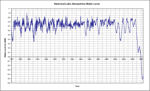
Fig. 3 Graph of Lake
Alexandrina's levels since 1978[14]
3.19
In 2008-2009, the Murray-Darling Basin Commission estimates that 350GL of
dilution flows for drinking water will flow into the lakes from the Murray.
Some additional water will come from local rainfall and runoff from the Mt
Lofty Ranges, but it is highly likely that water levels in the Lower Lakes will
continue to fall and almost certain that there will be no release of lake water
into the Coorong.
Lower Lakes
3.20
The low flows into the Lower Lakes have resulted in the drying of
wetland habitat, steadily increasing levels of salinity and has exposed sulphur
bearing sediments which have oxidised to form acid sulfate soils, releasing
sulphuric acid into the lakes.
Acid sulfate soils
3.21
Acid sulfate soils are formed when anoxic waterlogged sulphur bearing
sediments are allowed to dry out. Oxygen penetrates the soil, reacting with the
sulphur compounds, to form sulphuric acid. This acid is then washed out of the
soil to form acid runoff. The acids also solubilise aluminium and heavy metals
in the sediments.[15]
3.22
The Lower Lakes contain extensive areas of sulphur bearing sediments
below 0.0 AHD. As the lakes' levels fall, the shallow bottom profile exposes
extensive areas of lake bottom sediment, which oxidise to form acid sulfate
soil. At the same time, the overall volume of water in the lakes available to
dilute or 'buffer' the acid formed is reducing, resulting in a rapidly rising level
of acidity in the lake. While small quantities of acid can be absorbed by the
system, continued falls in lake levels have the potential to generate an
exponential increase in acidity and consequent environmental collapse. [16]
Dr Matt Hipsey described the problem:
Our best understanding at the moment is that we have what we
call a threshold event, where you would have a very large volume of acid
sulfate soil which is increasing exponentially. We have a reducing volume of
water to buffer that acidity. What happens is you have two exponential graphs
superimposed on each other and you end up with a critical value where all of a
sudden the lake can no longer withhold it. There is much uncertainty about when
that threshold event occurs, but it does seem to occur as a threshold event. It
is almost impossible to say what volume of water is going to be required. But
if I were a risk averse manager, I would like to ensure that the water level
was kept above negative one metre AHD.[17]
3.23
At the moment local rain and runoff from Mt Lofty Ranges has raised the
level of water in Lake Alexandrina to approximately -0.26m AHD, but it has
fallen as low as -0.55m in 2008. The critical level below which the impact of acid
sulfate soils becomes catastrophic is uncertain, but general consensus places
it at -0.5 AHD for Lake Albert and -1.0 to -1.2m AHD for Lake Alexandrina. Based
on projections from September 2008, if there are no significant increases in
inflows, these levels could be reached in mid to late 2009.
Salinity
3.24
Salinity levels in the lakes have been steadily rising. The Murray River
deposits approximately 500 000 tons of salt in the lakes every year. With no
outflow, this salt has been concentrated by evaporation. This has been
exacerbated by seepage of saline groundwater. With the lake level substantially
below sea level, sea water has been seeping through sandy sediment,
particularly under the Goolwa Barrage. The net effect has been steadily
increasing salinity levels. On 23 September, when Lake Alexandrina was at -0.29m
AHD, salinity was measured as 4044EC[18]
at Milang and 16 915 at Goolwa, although several witnesses referred to
measurements as high as 25 000. [19]
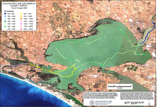
Fig 4 Plot of salinity levels measured in Lake Alexandrina.[20]
3.25
These rising salinity levels are affecting the fresh water ecosystem of
the lakes. Fresh water plant and marine life are suffering from the increasing
salinity and more estuarine and marine species are appearing in the lakes.[21]
3.26
Increased salinity has also rendered the lake water unsuitable for human
consumption for irrigation or watering stock.
The Coorong
3.27
Under natural conditions, the Coorong received significant fresh water
inputs from the Murray, the water courses of the southeast of South Australia
and the regional groundwater. As a result the Coorong was regularly flushed
with fresh water inputs from both the north and the south which would have
reset the estuarine conditions and replenished its nutrient and organic matter.
Under current conditions, flows from the Murray have been the major fresh water
inputs to the Coorong because of extensive drainage of the southeast and
alterations to the regional groundwater system.[22]
3.28
Salinity distribution in the Coorong is determined by evaporation,
mixing of water both within and between lagoons, fresh water inputs via barrage
releases and ground water. In the Coorong, the silting up of the mouth has
resulted in reduced tidal exchange, particularly into the South Lagoon. When
coupled with a reduction of fresh groundwater seepage and a reduction in runoff
from the upper southeast drainage scheme area, steady evaporation has resulted
in worsening hypersaline conditions which are exceeding the levels that even
the specialised ecosystems in this area are able to cope with.
3.29
In 2005-06 it was noted that more than 75 per cent of the Coorong has
salinities greater than double that of sea water (>110 000EC) with
salinities reaching up to seven times sea water (>380 000EC) in the
South Lagoon. Salinities of 100 000EC are a critical threshold for many
ecological components and processes. The length of time that salinities of this
magnitude persist determine the extent of the damage caused as most species can
tolerate only short periods of less than 30 days exposure to high salinities.[23]
Economic and social impact
3.30
The Lower Lakes and the Coorong form the basis of the local economy and
contribute significantly to the South Australian economy. The area surrounding
the Coorong and Lower Lakes supports extensive economic industries including
irrigated and dryland agriculture, commercial fishing and cockle harvesting,
tourism, and some urban developments. Each of these activities is in some way
dependent upon, and at the same time has an impact on, the ecological health of
the system.[24]
3.31
The committee received a range of evidence that stressed the
significance of the Lower Lakes and the Coorong to local industries:
Until recently, the Lower Lakes and the Coorong supported a
thriving dairy industry, irrigated horticulture, fodder production and beef
cattle production. [25]
Between Goolwa and Wellington, there is a $100 million a year
boating-tourism industry. We have within our council area some 8,000 hectares
of vines, which on average is about an $800 million a year industry.[26]
3.32
The Lower Lakes, and Coorong region is also of high cultural, economic,
spiritual and social value to the Ngarrindjeri people. The Ngarrindjeri are the
traditional owners of the region and maintain a continuous, strong relationship
with their land and waters.[27]
3.33
However, the exposure of acid sulfate soil threatens an environmental
collapse in the Lower Lakes. The Ramsar listed wetlands could be irreparably
damaged. Local communities which rely on tourism, fishing and the dairy
industry are already suffering and would be further damaged.
3.34
In the Coorong, increasing hypersalinity will reduce biodiversity,
accentuating the damage to the area's natural value and the commercial fishing
industry.
3.35
The town of Goolwa is particularly dependent on boating and the current
low levels in the Lake Alexandrina have already rendered the majority of its
dock facilities useless.
Current management of the Lower Lakes and Coorong
The Living Murray Initiative
3.36
As mentioned in the previous chapter, the Lower Lakes and Coorong,
together with the Murray Mouth, has been identified as one of six Icon Sites
under the Living Murray Initiative. The Living Murray Initiative includes a
water recovery target of an average of 500GL of new environmental water per
year by 2009. This is being achieved through a coordinated effort by the state
and federal governments and the MDBC using a combination of infrastructure,
regulatory, urban and market based water recovery projects.[28]
3.37
To date 133GL of water entitlements has been recovered under the Living
Murray Initiative; however, the actual volume of water available at any time is
dependent on the allocations. At present there is only 1.218GL of water available
to the environment in 2008-09 although this may increase modestly if higher
allocations are announced against entitlements this water year. These low
allocation figures affect both irrigation and environmental entitlements
equally.
3.38
Environmental watering of Icon Sites has been managed under the Living
Murray Environmental Watering Plan since 2005-06. This plan provides for
coordinated watering at Icon Sites, regardless of the type of environmental
entitlement or source of water. A limited amount of watering has been
undertaken during 2006-07 and 2007-08 but the MDBC considers that this has
'demonstrated that excellent, though localised, environmental outcomes can be
achieved where water is actively provided and managed for environmental
outcomes.'[29]
MDBC Ministerial Council
Initiatives
3.39
In March 2008 the MDBC Ministerial Council (the Ministerial Council)
approved the Lake Albert Water Level Management project at a budget of $6
million. A temporary structure has been built to separate the lakes and pumping
from Lake Alexandrina to Lake Albert commenced on 2 May 2008.
3.40
The Ministerial Council also directed the MDBC to develop risk
management strategies and future management options for the Coorong and Lower Lakes
and to report to Council in October 2008. The Ministerial Council has agreed to
the following short term management objectives (defined as the next 6-24 months):
- Avoid irreversible damage, especially acidification of the Lakes
system;
- Actions taken must not adversely impact on water quality for
major water supply offtakes.
- Use treatments that as far as possible do not compromise
long-term options.
3.41
To achieve these management objectives, South Australian agencies have
developed critical acidification thresholds and water level management
triggers. The modelling for these thresholds and triggers is being regularly
reviewed against actual data to improve its predictive capacity.
3.42
A draft real time management strategy for 2008-09 is currently being
considered by Ministerial Council. This strategy is being supported by a number
of ongoing activities including regular review of lake levels, water quality
and acidification data and forecasting of the projected date to reach the water
level management trigger. Field trials are also being undertaken in relation to
the potential for bioremediation to manage localised acid affected areas.
3.43
The MDBC also advised the committee that longer term options have been
identified in relation to three scenarios:
- a fresh water Lakes system;
- a variable Lakes system (fresh with times of estuarine at low
flow); and,
- a marine/estuarine Lakes system.
3.44
The MDBC told the committee that these scenarios will be developed in
the light of long term water availability, climate change, and sea level rise
forecasts. The identification of the potential risks of each scenarios will be
identified and assessed including the impact of sea water on environmental,
economic and social values should an estuarine/marine system be seen as a
possible future. The first report on the development of these longer term
options is expected to be provided to the MDBC and the Ministerial Council in
early 2009.[30]
Commonwealth Government Initiatives
3.45
Under the Water for the Future initiative the Australian Government
recently announced $320 million in Commonwealth funding. This includes:
- $120 million towards the piping of fresh water supplies to take
to dependant communities and
- $200 million towards the development of a long term plan to
address the environmental issues facing the Lower Lakes and Coorong.
3.46
The Water for the Future program has also allocated $3.1 billion for the
purchase of water entitlements to be held by the Commonwealth Environment Water
Holder, together with other initiatives which will also see the water
efficiencies return to the rivers.
Navigation: Previous Page | Contents | Next Page