Assessment and modelling capacity
3.1
This chapter examines the adequacy of fire assessment and modelling
capacity for the Tasmanian Wilderness World Heritage Area (TWWHA).[1]
The committee heard that the current fire models do not consider the
unique vegetation types found in the World Heritage area and there are no plans
to rectify the situation. This chapter discusses the use of Australian fire
models and Tasmania's layered map of fire sensitive vegetation communities
(TASVEG), before examining current efforts to provide a Tasmania-specific fire
model.
Australian fire models
3.2
In Australia, fire assessment and modelling has traditionally focused on
specific fire models for each general class of vegetation in which bushfires occur.[2]
This approach contrasts with other countries—such as the United States of
America—where a general fire spread model (the Rothermel model) is used, with
fuel specific models employed to make more precise predictions.[3]
3.3
According to the Commonwealth Scientific and Industrial Research
Organisation (CSIRO), the Australian approach has the advantage of enabling
development and refinement of a model for a specific fuel type, without
affecting predictions for other fuel types (a fault of the Rothermel model).
The downside to this approach is that the known effect of a particular fuel
type on fire behaviour is required before a fire behaviour model can be
developed for that fuel type.[4]
TWWHA fire model
3.4
CSIRO advised that Tasmania has fuel types for which there is no fire model
or no suitable model for wildfire conditions:
These include peat, rainforest, wet heath, alpine forest,
alpine scrub and wet eucalypt forest, which represent many of the predominant
fuel types found in sensitive and Tasmanian Wilderness Heritage Areas.
The only fire behaviour model that has been developed specifically for a
Tasmanian fuel type is the Buttongrass model of Marsden‐Smedley and Catchpole (1995). The applicability
of existing wildfire behaviour models to other Tasmanian fuel types is unknown.[5]
3.5
Dr Andrew Sullivan from CSIRO indicated that, as a result, Tasmanian fire
agencies cannot make accurate predictions of fire spread in the TWWHA.[6]
Professor David Bowman, an environmental change biologist, agreed that the
inaccuracy of the fire models is challenging for fire managers.[7]
3.6
In relation to the 2016 bushfires, the Tasmanian Greens said:
The modelling available to the State Government predicted the
fires would not progress through these vegetation types [alpine vegetation and
rainforest], as the inputs to this modelling defined these landscapes as too moist
to burn. Put simply, the fires burnt where they were not meant to burn.[8]
3.7
Some witnesses, including Dr Tony Press from the Tasmanian Wilderness
World Heritage Bushfire and Climate Change Research Project and Mr Geoff Law
from The Wilderness Society (Tasmania), contended that there is a critical need
for a fire model based on the vegetation types and organic soils found in the
TWWHA in order to manage its ecosystem.[9]
3.8
Dr Sullivan agreed:
You need to be able to determine the conditions in which
fires are likely to begin to spread—so the initiation. There is lots of dry
lightning that occurs that does not start fires, so we need to be able to
determine when it is likely that dry lightning is going to start a fire. When
that fire does start, we need to know how fast it is going to move and where it
is going to spread to. We also need to know under what conditions it is
likely to go out.[10]
3.9
Professor Bowman indicated that the precursor to developing a specific fire
model for the TWWHA is targeted landscape ecology research. Such research would
enable detailed assessment of how fire sensitive vegetation has been affected
by recent fires:
Specifically, I recommend landscape ecology analyses...are required
to understand the spread and impact of the recent fire in western Tasmania. This
will help us better understand the effect of weather conditions, vegetation and
terrain and land management history including wildfires and planned burns. Such
analyses enable the development of evidence-based management.[11]
3.10
The committee notes that, in addition to ecology and fire management, there
is an argument for the adequate modelling of fire behaviour for 'life
safety' reasons.[12]
Phoenix RapidFire
3.11
Submitters commented on Phoenix RapidFire, a computer program used by
the Tasmanian Government to predict the likely spread of a bushfire. One of the
developers of the program, Kevin Tolhurst, a Forestry Professor at the
Melbourne Sustainable Society Institute, has published how the program
simulates likely fire spread:
Within seconds, the program crunches data on weather, wind,
vegetation, the slope of the land and how dry the bush is. It turns this into a
map of where the fire is likely to go, overlaid on Google Earth, and displays
the results as a video. The program also diagnoses the type of fire—how hot
will it burn? How high will the flames go? Where might embers land? Trained
fire analysts monitor and act on the results.[13]
3.12
One of the program developers—the Bushfire and Natural Hazards Co‑operative
Research Centre (BNH CRC)—described Phoenix RapidFire as 'one of the best
[simulators] available in Australia'.[14]
Its submission acknowledged however that 'empirical fire spread models are only
as good as the observations and fire behaviour models which have been used'.[15]
3.13
Further, Phoenix RapidFire has known limitations:
These limitations primarily occur at extreme fire danger
levels, where there is substantial interaction between the fire and the
atmosphere, which is why the Bushfire and Natural Hazards CRC has extensive
research underway to produce better fire spread models. However, the
simulations can also prove difficult at very low fire danger ratings levels in
the types of fuels seen in these fires. The models may predict the fires should
not spread and go out, but in peat they may continue to smoulder and reignite.[16]
3.14
The committee notes that Phoenix RapidFire is currently being 'updated'
to improve its accuracy, particularly in the areas of landscape dryness
measures, weather forecasting and the use of remote sensing products.[17]
TASVEG
3.15
The Department of Primary Industries, Parks, Water and Environment (Tas)
(DPIPWE) has mapped the fire sensitive vegetation communities of the TWWHA. According
to DPIPWE, this mapping enables Tasmanian fire agencies to develop plans for
priority protection in the event of fire.[18]
3.16
However, the Tasmanian National Parks Association expressed concern that
the database and published map (TASVEG) contain errors. Its submission
described a sample review of the underlying data that it found to contain a
number of spatial and coding errors:
If this is the case in this small sample area then it is
possible that many more such errors occur elsewhere. This has major
implications for GIS‑based assessments of fire impacts (e.g. areas of
sensitive vegetation types burnt) and it is self-evident that it is impossible
to effectively prioritise fire-fighting efforts if the locations of the values
being protected are not accurately known. It is therefore essential that a
state-wide review of the accuracy of mapping of all fire sensitive natural
values is undertaken, and resources made available to improve the quality of
such data if it is determined to be deficient.[19]
3.17
To illustrate the inadequacies of TASVEG, Mr Nicholas Sawyer from the Tasmanian
National Parks Association provided a photograph, said to show a hillside marked
by TASVEG as an extensive Pencil Pine forest.
Figure 3.1: Frozen Lagoon,
south-west of Lake Mackenzie on the Central Plateau
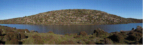
Source: Additional
Information provided by Tasmanian National Parks Association, received 11
November 2016
3.18
Mr John Whittington, Secretary of DPIPWE, responded to this concern,
saying that TASVEG is an amalgam of data from a range of sources and is not
designed to pinpoint the location of vegetation: 'it is at a coarser scale than
that'. Mr Whittington went on to comment:
People run into trouble with TASVEG when they use it for a
purpose that it is not capable of supporting. I am confident that TASVEG is as
good as any vegetation-mapping capacity around the nation, but it needs to be
used appropriately.[20]
3.19
The committee notes the Tasmania Fire Service's response that finer
scale vegetation mapping would be of assistance.[21]
Current efforts to develop a Tasmania-specific fire model
3.20
Submitters and witnesses indicated that there is no research currently
being undertaken to support the development of a Tasmania-specific fire model.
3.21
When the committee sought further evidence of specific fire modelling,
from CSIRO, a representative stated that CSIRO was not aware of any proposal to
conduct ecology landscape research, although the organisation has a long
history of bushfire research, including the development of tools to predict the
behaviour and spread of bushfires.[22]
3.22
Dr Sullivan told the committee that ecology landscape research has not
been prioritised, with research focusing on 'life safety' in the past 10 years.
This focus has been accompanied by a policy shift away from management toward a
response-driven approach.[23]
3.23
Dr Sullivan suggested also that the development of fire spread models may
have decreased in recent years due to reliance upon existing models that are
assumed to work 'well enough'. He described how experienced individuals often
fill the gap but forewarned against the retirement of these individuals:
Because we do not have formal fire behaviour models does not
mean that an individual who has experience cannot undertake their own
predictions. So quite often the gap gets filled by well-experienced people who
have been doing it for many years. The problem is that, when they retire and
move on, that gap becomes evident and people assume, 'Oh, they were just using
whatever model was available at the time,' and continue on without actually
identifying that there is a gap in the knowledge, because the expert knowledge
that had been contained in that individual filled that gap for them.[24]
3.24
CSIRO advised that a multi-agency approach would produce a practical
fire model for Tasmania, and CSIRO was in a prime position to lead such
research. However, this would require governments to prioritise ecology
landscape research, including through additional funding:
There is only so much that can be done given the scale that
we have, and in order to ramp up and solve the problem as comprehensively as it
needs to be it may need a larger scale, which could be beyond CSIRO's capacity
at this point.[25]
3.25
Other witnesses spoke about research funding difficulties. For example, Professor
Bowman told the committee that there are various funding models such as
collaboration with industry partners, competitive Australian Research Grants or
funding through the BNH CRC.[26]
3.26
Dr Richard Thornton, Chief Executive Officer of the BNH CRC, indicated
that funding is always difficult, with its budget largely allocated through
forward years. This allows only for 'elements that we can do in the short
term'.[27]
3.27
In addition, Dr Thornton explained that, for the BNH CRC, the 'focus has
always been on the national issues that get to the heart of some of the
systemic problems that we see, not so much on the local issues'. He indicated
that, for Tasmania‑specific issues, the Tasmanian Government could fund a
research portfolio but it would still be 'a balance' of priorities.[28]
3.28
Finally, Professor Bowman argued that the Commonwealth Department of the
Environment and Energy (DEE) and DPIPWE are not well integrated with the
university sector, resulting in ad hoc management and research for the TWWHA:
...there is no real go-to place for research in the World
Heritage area. It is just a whole lot of very committed people who are doing
things and shift shaping as the opportunities arise. There is not really a
central organising principle and there is not a reliable income stream for
sustaining the research—certainly in the university sector.[29]
Government responses
3.29
In February, the DEE informed the Senate Environment and Communications Legislation
Committee that the department has not undertaken any modelling to prepare for
and manage increased fire risk in the TWWHA. An officer advised that this is
the responsibility of the Tasmanian Government.[30]
3.30
For this inquiry, Mr Chris Arnol, Chief Officer of the Tasmania Fire
Service, explained that a specific fire model was never developed for the
TWWHA, as the need was not anticipated. However, Mr Arnol recognised:
...it would be better to have modelling for Tasmanian
environments ...What has been modelled in New South Wales does not necessarily
apply in Tasmania...so we have to ground-truth them or check them...When we look at
the range of models, there is, in my view, a fair bit of work that we could do
there.[31]
3.31
A representative from the Attorney-General's Department (AGD), Mr Mark
Crosweller, warned however that modelling is a recent phenomenon that does not
necessarily supplant or surpass the assessment of a professional firefighter:
...firefighters are trained to read the fireground to
anticipate fire conditions, rates of spread, intensities and all that comes
with it, separate from technology. Technology can assist. It is becoming more
useful. Some modelling has been very inaccurate compared to manifest
circumstances, so to rely only on modelling could be more dangerous than having
no modelling at all. Modelling is getting better, but I do not think that one
can assume that modelling supplants or surpasses the capacity for understanding
fire behaviour, as a practitioner.[32]
3.32
Mr Crosweller noted that Australian, state and territory governments are
currently collaborating on the National Fire Danger Rating System–Probabilistic
Framework Project. This project is being managed by the NSW Rural Fire Service
and aims to develop:
...a new consequence-based fire danger rating system able to
integrate a wide range of variables and link their complex interactions to the
probability of property loss. The project aims at delivering a spatially‑explicit
framework capable of generating daily maps representing the distribution of the
probability of property loss at 10Km spatial resolution.[33]
3.33
Mr Crosweller stated the project demonstrates that 'much research and
investment is going into fire modelling in predictive analysis and behaviour to
apply to multiple vegetation types across the landscape of Australia'.[34]
3.34
The committee notes that the first phase of the project will deliver a
prototype National Fire Danger Rating System based on the 'best currently
available science'. This means that the prototype will not encompass TWWHA vegetation
types for which there are no fire behaviour models (peat rainforest, wet heath
alpine forest, alpine scrub or wet eucalypt forest).[35]
Committee view
3.35
Fire assessment and modelling is a highly important tool for Tasmanian
fire agencies, enabling them to more accurately predict fire behaviour and
manage fires within their jurisdiction. However, CSIRO—and several
others—highlighted that there is no fire model suited to the specific needs of
the TWWHA. The committee is of the view that, had such a model been available,
the Tasmanian fire agencies would have been better prepared to respond to the
2016 bushfires. The committee considers that this deficiency should be
addressed as soon as possible, commencing with the necessary groundwork in
ecological landscape research.
3.36
In this context, the committee notes that the Tasmanian Government simulates
fire behaviour using Phoenix RapidFire, a software program that requires, and
will always require, current data. The committee has some concerns that reliance
upon such a program could exacerbate the challenges currently facing Tasmanian
fire agencies, especially as the program has known limitations in relation to
organic (peat) soils.
3.37
While several submitters and witnesses highlighted the critical need for
a Tasmania-specific fire model, the committee was surprised to learn that there
are no current plans for research to support the development of such a model.
One key reason for this appears to be a lack of funding. The committee
considers that the Australian and Tasmanian Governments should prioritise
ecology landscape research in the TWWHA, with long‑term funding provided
to enable the CSIRO to lead a multi‑agency research project on this issue.
The committee notes that the TWWHA is home to a number of endemic fauna species
(see chapter one) and that predicting fire behaviour and spread is important
also to the protection and conservation of fauna values.
Recommendation 2
3.38
The committee recommends that the Australian Government, in cooperation
with the Tasmanian Government:
- recognise the need to identify the ecological and biodiversity impacts
of fire on fire sensitive vegetation communities, organic soils and endemic
fauna species in the Tasmanian Wilderness World Heritage Area; and
-
allocate long-term funding to the Commonwealth Scientific and
Industrial Research Organisation and/or the Tasmanian Government to assist with
the development of fire assessment and modelling specifically suited to the
Tasmanian Wilderness World Heritage Area.
Navigation: Previous Page | Contents | Next Page