Changes in ocean temperatures, currents and
chemistry associated with climate change
2.1
This chapter provides an overview of the evidence presented to the
committee regarding warming ocean temperatures, changing ocean chemistry and
altering ocean currents. Projections of further rises in ocean temperatures,
rising sea levels and more extreme weather events due to climate change are
also discussed.
Rising ocean temperatures
2.2
The Institute for Marine and Antarctic Studies (IMAS)
advised that '[s]ea‑surface temperatures trends for the period 1901 to
2012 are rising everywhere except in the northern Atlantic'. Since 1901, the
global average temperature change has been recorded as approximately 0.89ºC
[0.69–1.08ºC], with an average change of 0.075ºC to 0.083ºC (±0.013ºC) per decade.[1]
The Bureau of Meteorology has reported that surface temperatures were the
highest on record in 2016 both globally and in the oceans around Australia. For
the oceans around Australia, the Bureau reported that the annual mean sea
surface temperatures were 0.73°C above average (records date back to 1910). The
previous record of 0.64ºC above average occurred in 2010.[2]
2.3
IMAS explained that the largest temperature changes have been recorded
in the surface ocean, with smaller changes occurring in deeper layers.
Available evidence includes the following:
-
the top 75 metres of the ocean has warmed at a rate of 0.11ºC
[0.09–0.13ºC] per decade since 1971, which is the same rate, within errors, as
the rate of global average surface temperature warming; and
-
below the top 75 metres, '[t]here is good evidence that the deep
ocean below 3000 metres has warmed, and that the mid-depth ocean (between 2000
to 3000 metres) has not warmed, consistent with our understanding of global
ocean circulation'.[3]
2.4
IMAS added that the 'south east region of Australia is recognised as one
of the fastest warming regions globally'. Evidence supporting this includes:
-
direct observations since the 1940s indicating that warming in
this region 'is approximately 3.8 times the global average'; and
-
sea surface temperatures over a 50-year period indicating that
this region 'is warming faster than 90% of the ocean'.[4]
2.5
Professor Stewart Frusher from IMAS observed that although it 'is often
very difficult to attribute the exact cause of why something has occurred...the
weight of evidence that underpins the changes we are seeing on particularly our
south-eastern seaboard indicates that our waters are warming'. To demonstrate, Professor
Frusher continued by referring to warming waters off Maria Island, which is
located off the east coast of Tasmania. Professor Frusher stated:
One of the few long-term datasets we have is off Maria
Island. Fortunately, they have maintained measuring the water temperature there
since the 1940s. The consistent trend in that data is an increase in water
temperature over that period to the extent that the water that was off Eden in
southern New South Wales in the 1940s is now equivalent to what we see off
Maria Island. That water body is now equivalent. When you think about the
changes, it includes looking at those ecosystems which were off Eden in the
1940s and the ones off Maria Island now.[5]
2.6
Dr Neville Barrett, also from IMAS, added that the climate predictions
for this area of Tasmania is that the climate will be the same as Batemans Bay
in New South Wales by 'at best case, 2100 and, at worst case, 2060'.[6]
2.7
High temperatures have also been recorded elsewhere. IMAS explained that
the term 'marine heat wave' has been coined to account for observations of
extreme temperatures in regions of the oceans.[7]
Marine heat wave events were recorded in Western Australia (2011) and the Great
Barrier Reef (2016).[8]
2.8
During the major El Niño Southern Oscillation Event of late 2015 to
April 2016, the oceanic temperature at Thursday Island reached an average
daily peak of 31.90ºC on 13 March 2016, which is 0.4ºC higher than the peak of
2010.[9]
The Western Australian marine heat wave event 'resulted in the highest sea
surface temperatures off south-western Australia on record'.[10]
A journal article on the heat wave event provided the following overview of
recorded temperature changes:
Following temperature anomalies within ±1 °C for most of
2010, as well as the dominantly negative temperature anomalies off the upper
west coast during the first half of 2010 (likely a result of the 2009/2010 El
Niño event), the water began to warm from October and climbed steadily into
summer. There was a rapid phase transition from the "warm pool" El
Niño to La Niña conditions in 2010, probably due to the Indian Ocean
warming...The peak anomaly at Ningaloo was 3 °C in January, and there were even
higher peaks between Shark Bay and the Abrolhos Islands in February. Down at
Cape Leeuwin, the peak temperature was about 2.5 °C and occurred in March.
These elevated temperatures gradually decayed to more typical levels between
April and July.[11]
2.9
The frequency of these marine heat wave events is increasing.[12]
Dr Janice Lough, Senior Principal Research Scientist, Australian Institute of
Marine Science (AIMS), explained that core records based on isotopic records
trapped in coral skeletons indicate that recent warm events 'are exceptional,
going back to at least...about 1600'.[13]
2.10
Figure 2.1 illustrates how sea surface temperatures in the oceans around
Australia in 2016 compare to historical records. Figure 2.2 provides detailed
maps illustrating surface sea temperatures off the coast of Tasmania between
2010 and 2017. Further graphs and charts indicating historical trends in
temperature changes were provided by CSIRO.[14]
Figure 2.1: Australian region sea
surface temperature (SST) deciles: annual 2016
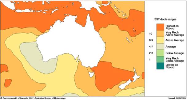
Note: distribution based on
gridded data.
Source: Bureau of Meteorology,
'Annual climate statement 2016', 5 January 2017, www.bom.gov.au/climate/current/annual/aus/2016
(accessed 5 January 2017); from the NOAA Extended Reconstructed Sea Surface
Temperature dataset, ERSST v4.
2.11
IMAS explained that projected changes in ocean temperatures 'depend very
strongly on the emissions pathway taken by society'. IMAS advised that:
-
under the Intergovernmental Panel on Climate Change's low emissions
pathway (RCP2.6), by the end of the 21st century Australian marine temperatures
are projected to rise by a further 0.5–1.0ºC from the 1986–2005 base period;
and
-
under the high emissions pathway (RCP8.5), it is projected that
Australian marine temperatures will rise by 2–4ºC (over the same period as
above).[15]
Figure 2.2: Sea surface temperatures on 23 November
2010–2017 off the coast of Tasmania
Source:
IMOS, Sea Surface Temperature maps, http://oceancurrent.imos.org.au/sst.php
(accessed 28 November 2017).
Changing ocean currents
2.12
Evidence received during this inquiry commented on developments
regarding the East Australian Current and the Leeuwin Current.
2.13
The East Australian Current is the largest ocean current close to the
Australian coastline. The current is formed from the remnants of the South
Equatorial Current that flow southward after crossing the Coral Sea. It has a
significant influence on the marine environment off the east coast of Australia
due to the warmer ocean water it carries southward. The current is around 100
kilometres wide and transports 40 million cubic metres of water southward
each second at up to 3 kilometres per hour.[16]
2.14
The warming observed off Maria Island, Tasmania, since the 1940s referred
to in paragraph 2.5 is related to the increased strength of the East Australian
Current.[17]
CSIRO advised that climate models suggest that, by 2060, the strength of the
current will have increased by 12 per cent in the core area and by 35 per cent
in the poleward extension.[18]
2.15
In addition to the evidence of a strengthening East Australian Current
with an increased southwards reach, changes in the formation of eddies[19]
are also of concern to scientists. IMAS and the Sydney
Institute of Marine Science (SIMS) explained that the frequency of eddy formation
is a key feature of the East Australian Current.[20]
IMAS submitted that 'an increased frequency of sudden warming events off
Tasmania's east coast' could occur as a result of potential increases in eddy
activity, with eddies lasting longer.[21]
The Fisheries Research and Development Corporation (FRDC) provided the
following evidence about eddies observed in that region:
Scientists have noted a trend in eddies off Tasmania becoming
larger, stronger and more frequent. Following the 1990s, eddy
kinetic energy (EKE) increased gradually both north...and south...of Bass
Strait, with a huge spike in eddy activity off Tasmania (8 times the average
EKE of the 1990s) in 2014...This trend is in agreement with climate modelling but
there has been a dramatic increase over the last couple of years.[22]
2.16
Similarly, CSIRO submitted that:
For the Tasmanian coast, it is expected the water will
continue to warm faster than the rest of the world as more warm East Australian
Water moves southward with a strengthening...[East Australian Current] and
increased generation of its eddies.[23]
2.17
A detailed description of how changing ocean currents are affecting
Australian waters was provided by Dr Barrett as part of an explanation of the
attributes that are making Tasmania a global hot spot for ocean warming. Dr
Barrett stated:
A big part of it, really, is the fact that we are at the
confluence of a range of different current systems. We have the East Australian
Current coming down the eastern Australian coastline, obviously, and
influencing Tasmania on that side. Then we have subantarctic water that bathes
the southern parts of Tasmania to some degree and we have the tail end of the
Leeuwin Current coming over from Western Australia. All these things are in a
dynamic balance over the years and have influenced us in various ways.
But as the waters have warmed up in eastern Australia, that
East Australian Current is starting to flow more strongly down the eastern
Australian coastline and it is starting to overdominate the other current
systems that typically have influenced us. So we have had a real increase
through time of the temperature that this water actually brings onto our coastline.[24]
2.18
Increased eddy formation in this region is expected to have implications
for fish stocks, which are discussed in Chapter 3.
2.19
Although the East Australian Current attracted significant comment,
evidence was also received about the Leeuwin Current. The Leeuwin Current is
off the coast of west and south-western Australia: it 'sweeps down Australia's
west coast, from about the North West Cape and can extend as far as the Great
Australian Bight and the southwest of Tasmania'.[25]
The
current 'brings warm, low-salinity tropical waters southwards and
then eastwards along the south coast of the continent'.[26]
CSIRO explained that, unlike the East Australian Current, the Leeuwin Current
has weakened in strength over the past 50 years by 10–30 per cent. The current
is predicted to weaken further by 15 per cent by 2060.[27]
Rising sea levels
2.20
Rising sea levels linked to climate change were noted. The Australian Fisheries Management Authority (AFMA) referred
to research indicating that, globally, the average sea level has risen by 0.19
metres between 1901 and 2010. Furthermore, the rate of sea level rise has
increased: for the period 1901–2010 it was measured at 1.7 millimetres per
year whereas over the period 1993–2010 the rate was 3.2 millimetres per
year.[28]
By 2100, it is projected that sea levels could have risen by up to 0.8 metres.[29]
2.21
Rates of sea level rise that are greater than the global average have
been observed in and near Australian waters. In the Torres Strait, research
published in 2010 indicated that the sea level had risen at approximately six
millimetres per year. In waters near Papua New Guinea, an annual average
increase of seven millimetres since 1993 has been measured.[30]
Changing ocean chemistry
2.22
Rising carbon dioxide levels in the atmosphere has caused the surface
ocean to acidify and this trend is expected to continue. AIMS provided the
following explanation of how rising levels of carbon dioxide in the atmosphere
leads to ocean acidification:
Concentrations of carbon dioxide (CO2)
are rising rapidly in the atmosphere, due to the burning of fossil fuels and
deforestation, and about 25% of this extra CO2 added to the
atmosphere is being absorbed by the oceans.
When atmospheric CO2 dissolves in seawater, it
first forms carbonic acid and triggers a cascade of other chemical changes. The
concentrations of hydrogen ions increase and carbonate ions decline. In fact,
the concentrations of hydrogen ions have already increased by 30% in the
seawater compared with preindustrial times.[31]
2.23
IMAS explained that the 'pH of surface waters of the ocean has decreased
by about 0.1 since the pre-industrial era, an increase of 26% in hydrogen ion
concentrations'.[32]
AIMS added that the pH of the ocean is 'predicted to further decline by 0.2–0.4
by the end of this century'. This acidification of the ocean reduces the
ability of marine organisms such as corals to calcify and may also 'lead to
behavioural changes in fishes and invertebrates'.[33]
2.24
IMAS also noted that the 'concentration of oxygen in the oceans is
changing'. IMAS explained:
...in the main thermocline it
has decreased and the tropical oxygen minimum zones have expanded, and these
changes have also been attributed to human influence.[34]
2.25
The FRDC submitted that changes to ocean chemistry are 'the less
understood' of the changes to physical attributes of oceans.[35]
Extreme weather events
2.26
In tropical Australia, coastal areas are projected 'to experience more
intense storms and severe weather events'.[36]
An increase in average cyclone intensity is also projected as the climate warms.
Incidences of strong tropical cyclones are expected to increase for particular
regions as follows:
-
southern Great Barrier Reef—from one every 25 or more years at
present to one every 6–12 years; and
-
Western Australian coast (Pilbara to southern Kimberley)—from one
every 10 years to one every 7.5 years.[37]
2.27
Among other things, the increased frequency and intensity of severe
weather events are expected to have implications for fish stocks and the health
of coral reefs. These consequences are discussed in Chapter 3.
Overview of monitoring arrangements
2.28
This chapter has provided an overview of the recent and projected
changes in ocean temperatures, currents and chemistry associated with climate
change. This following section briefly outlines the infrastructure used to
observe and monitor these changes. Key knowledge gaps and challenges faced in considering
changes in ocean temperatures, currents and chemistry associated with climate
change are then discussed.
2.29
At present, the Integrated Marine Observing System (IMOS)
provides key monitoring infrastructure for observing developments in
Australia's marine environment. IMOS, which was established in 2006, is operated
by several institutions as a joint venture. It receives core funding from the
Australian Government under the National Collaborative
Research Infrastructure Strategy (NCRIS). Co-investment from state
governments and operational partners also support IMOS.[38]
2.30
IMOS is 'a national collaborative research infrastructure' involving the
deployment of a wide range of observing equipment in the oceans around
Australia. More specifically, IMOS is 'a fully-integrated, national system,
observing at ocean‑basin and regional scales, and covering physical,
chemical and biological variables'.[39]
IMOS utilises a wide range of techniques including: Argo Floats (autonomous
profiling floats), Ships of Opportunity (volunteer commercial and research
vessels), deep water moorings, ocean gliders, autonomous underwater vehicles, a
national mooring network,[40]
ocean radar, animal tracking, wireless sensor networks and satellite remote
sensing.[41]
Some of these techniques utilise long-running measurement programs, such as a
70-year history of recording temperature and salinity off Sydney.[42]
2.31
IMOS observations focus on the following five major research themes:
long‑term ocean change; climate variability and weather extremes;
boundary currents; continental shelf and coastal processes; and ecosystem
responses. The data collected as part of IMOS are available for use 'by the
entire Australian marine and climate science community and its international
collaborators'.[43]
2.32
Dr Alan Jordan, Principal Research Scientist, New South Wales Department
of Primary Industries, described IMOS as the 'fundamental building block' of
the data relied on for ocean temperatures. Dr Jordan explained:
If we did not have that nationally approved infrastructure
process underway, we would not have the sort of data that we collect. It has
managed to massively increase our understanding of how the system operates, why
we get upwelling events in certain places, and the derivation of the satellite
imagery and the temperature loggers. Unless you have got instrumentation out
there that is measuring this stuff, it is purely speculative. It is a big water
column out there, and the satellites only see about the top five centimetres,
so what is going on under that five centimetres is where the whole
three-dimensional nature of the ocean works, and having things like the gliders
that profile the water column is fundamental. The New South Wales government
has supported the IMOS program for a long time, and we see no reason not to
continue that support. It will be a fundamental component of our long-term
monitoring program.[44]
2.33
Research is also informed by the real-time global sea surface temperature
(SST) analysis developed in the United States of America by the National
Oceanic and Atmospheric Administration. For example, research into the 2011
marine heat wave off the coast of Western Australia utilised Reynolds SST
analysis (named after Richard Reynolds from the National Climatic Data
Center, now the National Centers for Environmental Information, who developed
the analysis). This large-scale SST analysis supplemented local
temperature monitoring that also informed the research.[45]
2.34
Another example of long-term monitoring is at the Great Barrier Reef. The long-term
monitoring program undertaken by AIMS has been surveying the health of 47
midshore and offshore reefs across the Great Barrier Reef region for over 20
years.[46]
In addition to the AIMS monitoring program, Professor David Booth explained
that there is a smaller monitoring effort undertaken 'on a shoestring'.
Professor Booth advised that, in the early 1990s, he was located with a team undertaking
monitoring at the Great Barrier Reef. The professor stated that the team has
'done some amazing work', which enables assessments to be made about causes of
change in the Reef, such as the degree to which damage has been caused by
crown-of-thorns starfish and coral bleaching.[47]
Knowledge gaps and other considerations
2.35
In considering changes in ocean temperatures, currents and chemistry
associated with climate change, it is important to note the difficulties
scientists face in determining whether, and to what extent, developments are
linked to climate change. This was recognised by the scientific organisations
that presented evidence to the committee; for instance, the FRDC noted 'there
will always be levels of uncertainty due to the confounding nature of
separating climate variability from climate change'.[48]
2.36
Professor Gustaaf Hallegraeff from IMAS also made observations about the
difficulties faced by researchers considering the implications of climate
change on the marine environment. He stated 'there is no doubt' that Earth's
climate has been changing throughout time; however stated that '[t]he only
thing that is different is that it is changing so rapidly now'. The professor
explained that this has implications for research conclusions:
The only thing that is different is that it is changing so
rapidly now. We cannot find any precedents in the history of this planet.
We are trying desperately to understand what is going on. We are trying to
predict what a good spot is going to be or which fisheries could be aquaculture
in the future. We have some successes, but in general that is the
experience of my discipline: marine ecosystems, under climate change, are
becoming much more unpredictable.[49]
2.37
Professor Hallegraeff added that within the scientific community, even
at a localised level in cities such as Hobart, there is an ongoing debate about
how close the correlation between rising emissions and warming oceans or rising
ocean temperatures is. Regarding the warming water temperatures on the east
coast of Tasmania, Professor Hallegraeff noted:
...we can see a global signal of warming, but the much bigger
signal is a shift in east Australian currents. Even within our institute there
is still a big discussion: is that shift in that warm current part of the
global warming signal? A scientist at CSIRO, Andrew Lenton, claims that this
actually links to the ozone hole and the atmospheric air currents going faster
and spinning with it the east Australian currents signal.
And then, of course, what we had in 2016, this marine
heatwave, was yet another warming signal on top of an El Nino event that
affected the whole Pacific. The heatwave did not just happen on the east coast
of Tasmania; it also happened in Chile, where it did enormous damage to
salmon aquaculture, and on the northwest coast of America, where they had all
kinds of strange problems with what they call the hot block. So there are a lot
of different phenomena that cause this warming, and attribution to greenhouse
warming per se—any reputable scientist would say there is lots of uncertainty.[50]
2.38
These comments notwithstanding, Professor Hallegraeff concluded:
The end product of what we are dealing with now, this warm
water, that is what we have to deal with and we have to adapt to it.[51]
2.39
Scientific organisations also noted that there are gaps in knowledge
about how climate change will affect the physical attributes of the oceans.
They argued that further research is required and, in particular, that there is
a need for long-term climate monitoring of the marine environment. For example,
IMAS submitted:
It is crucial that investment in IMOS, sensor arrays, and
modelling capacity at the regional scale is maintained to provide us with the
physical basis for assessing and understanding changes on ecosystems and
fisheries.[52]
2.40
IMAS informed the committee that, due to the small number of long-term
data sets, there is a lack of information available for understanding the
implications of climate change. Professor Frusher referred to work undertaken
by IMAS scientists in marine protected areas, which are 'one of the few areas
where we actually have continued long-term monitoring'. He added:
We have very little long-term monitoring in any other areas,
and it would be prudent, I would have thought, to actually have a range of
these around Australia as scientific sites. But, of course, being able to
maintain science in these areas is not a cheap prospect.[53]
2.41
The FRDC submitted that 'there is an ongoing need for continued science
investment', such as the deployment of sensor arrays from RV Investigator
and using the AIMS Sea Simulator (SeaSim) to understand the implications of
changing pH.[54]
2.42
Evidence regarding the need for long-term funding arrangements for climate
monitoring and research is considered further in Chapter 6.
2.43
Ocean acidification was highlighted as an issue that, in particular, needs
further research. AIMS submitted that although changes to ocean chemistry from
carbon dioxide were 'recognised more than 50 years ago', this development has
'only recently emerged as an important knowledge gap in marine science, and has
now become a global research priority'. In particular, AIMS noted that although
changes in the carbonate chemistry from rising atmospheric carbon dioxide
levels 'are relatively well understood' for the open ocean, this is not the
case for nearshore and shallow marine environments such as the Great Barrier
Reef where 'conditions are more variable due to biological processes'. AIMS
advised that the 'evidence base of how the ongoing changes in the seawater
chemistry will affect marine ecosystems continues to develop', including as a
result of research undertaken by AIMS scientists.[55]
2.44
The committee was also informed of efforts to improve the knowledge base
and address some of the uncertainties regarding ocean warming hot spots.
Regarding the uncertainties and limited knowledge about the hot spot off the
south east coast of Australia, Professor Stewart Frusher from IMAS explained
that researchers are looking to other hot spot regions globally to attempt to
improve their understanding. Professor Frusher stated:
We have identified the 24 top to see if we can learn and
provide lessons for them, as well. We may have to draw a lot of our global
community to actually see what happens, because places like the south-eastern
seaboard of Australia are almost like global experimental laboratories because
they are those things. That is where we are going to see these events happen
earliest.[56]
2.45
Finally, it was noted that climate change is one of several stressors on
the marine environment. In addition to climate change, Dr Alistair Hobday,
Senior Principal Research Scientist, CSIRO, identified coastal
development, pollution and marine plastics as the other main risks for the
oceans. Dr Hobday added that which risk ranks as the most serious varies in
different locations. Dr Hobday stated:
...for offshore species like tuna, I think climate change is
No. 1. For species that rely on estuaries for completing their life cycle, it
is coastal development, which is taking away mangroves or salt marsh or
seagrass habitat. Plastics I think is a big sleeper, and we are only just
starting to become aware of how big a problem plastics might be.[57]
Navigation: Previous Page | Contents | Next Page