Introduction
Referral and terms of reference
1.1
On 22 February 2016 the Senate referred the following matter for inquiry
and report by 12 May 2016:
The potential environmental, social
and economic impacts of BP's planned exploratory oil drilling project, and any
future oil or gas production in the Great Australian Bight, with particular
reference to:
- The effect of a potential drilling accident on marine and coastal
ecosystems, including:
-
impacts on existing marine reserves within the Bight,
-
impacts on whale and other cetacean populations, and
-
impacts on the marine environment;
-
social and economic impacts, including effects on tourism, commercial
fishing activities and other regional industries;
-
current research and scientific knowledge;
-
the capacity, or lack thereof, of government or private interests to
mitigate the effect of an oil spill; and
-
any other relevant matters.[1]
1.2
On 8 May 2016, the Governor-General issued a proclamation dissolving the
Senate and the House of Representatives from 9 am on 9 May 2016 for a general
election on 2 July 2016. As a result of the dissolution of the Senate, the committee
ceased to exist and the inquiry lapsed.
1.3
The 45th Parliament commenced on 30 August 2016 and members of this
committee were appointed on 1 September 2016. On 13 September 2016, the Senate
agreed to the committee's recommendation that this inquiry be re-adopted with a
reporting date of 29 March 2017. The Senate also agreed to the recommendation
that the committee have the power to consider and use the records of the Environment
and Communications References Committee appointed in the previous parliament
that related to this inquiry.[2]
Conduct of the inquiry
1.4
As noted above, the inquiry spans two parliaments—the 44th and 45th—with
the conduct of the inquiry interrupted by the dissolution of the Senate prior
to the 2016 general election.
Progress during the 44th Parliament
1.5
In accordance with its usual practice, the committee appointed in the
previous parliament advertised the inquiry on its website and wrote to relevant
individuals and organisations inviting submissions. The date for receipt of
submissions was 1 April 2016.
1.6
The committee received 63 submissions, which are listed at Appendix 1.
The public submissions are also available on the committee's website at https://www.aph.gov.au/Parliamentary_Business/Committees/Senate/Environment_and_Communications/Oil_drill_Great_Aus_Bight.
1.7
In addition to the published submissions, the committee received a
significant number of form letters which expressed opposition to oil or gas
drilling in the Great Australian Bight. The committee received three different
form letters, and agreed to publish an example of each type of form letter and
the number received on its website. A breakdown of the form letters by type is
at Appendix 1.
1.8
During the 44th Parliament, the committee conducted a hearing in
Adelaide on 28 April 2016. A list of witnesses who appeared at the hearing is
at Appendix 2.
Progress during the 45th Parliament
1.9
Following the re-adoption of the inquiry on 13 September 2016, the
committee published a further 22 submissions (numbers 64 to 85). The committee
also continued the program of public hearings with a public hearing held in
Adelaide on 16 November 2016, and a hearing in Canberra on 7 February
2017.
1.10
As above, further information on the submissions and witnesses who
participated in public hearings is at Appendices 1 and 2 respectively.
Termination of BP's proposed exploratory program
1.11
Following the re-adoption of the inquiry in the current Parliament, BP
announced that it would not be progressing its exploration drilling program in
the Great Australia Bight.[3]
Although BP is no longer active in the Great Australian Bight, other companies,
including Chevron, retain exploration licences. The matters related to BP's
previously planned exploratory drilling program remain active for these
projects.
Acknowledgement
1.12
The committee would like to thank the organisations and individuals who
provided evidence to the inquiry.
Structure of the report
1.13
Chapters 1 to 6 of this report contain an overview of the evidence
provided to the committee. Members of the committee have expressed their views
in additional comments attached to this report.
1.14
Chapters 1 to 6 are as follows:
-
Chapter 1 provides overview of Australia's oil and gas industry,
and BP's exploratory program as well as an introduction to the geographical,
social and economic features of the Great Australian Bight region.
-
Chapter 2 provides an overview of the regulatory framework
governing offshore oil and gas activities in Australia.
-
Chapter 3 canvasses issues raised in relation to the regulation
of the offshore oil and gas industry. This includes issues with the adequacy of
community consultation, and proponent and regulator transparency.
-
Chapter 4 examines the economic impact of oil and gas exploration
and production, at both the regional and national level.
-
Chapter 5 examines the potential effects of an oil spill on the
region's industries, wildlife, and ecosystems. It also examines the potential
impact of exploratory activities such as seismic surveying.
-
Chapter 6 examines the capacity of industry and government to
mitigate the effects of an oil spill.
Oil and gas production and use in Australia
1.15
Oil and gas exploration and production has been a significant
contributor to the Australian economy through export revenue, employment
opportunities, and regional development. In 2014–15, the oil and gas extraction
industry (both onshore and offshore) was estimated to contribute $31 billion to
industry gross value added, and to employ around 24,000 people. It also plays
an important role in maintaining global and domestic long term energy security.[4]
1.16
Most known oil resources in Australia are condensate and naturally
occurring liquid petroleum gas (LPG) associated with large offshore gas fields.
Australia has limited resources of crude oil, holding only approximately
0.2 per cent of world crude oil reserves. In 2014–15, Australia's
crude oil and condensate production declined by 5 per cent while naturally
occurring LPG production also fell by 11 per cent. These falls in output
continued the longer term decline of Australia's production of primary
petroleum.[5]
1.17
Australia is a net importer of crude oil and other refinery feedstock,
importing around 75 per cent of the crude oil it refines into liquid fuels, and
importing around 50 per cent of the refined liquid fuels in Australia.[6]
In 2014–15, crude oil imports were valued at $14.9 billion while imported
refined petroleum products were valued at $19.3 billion.[7]
1.18
The Australian Petroleum Production and Exploration Association (APPEA)
submitted that Australia's consumption of oil and natural gas is expected to
remain strong through to 2050, and as such, the continual replacement of energy
reserves will be required as established reserves are depleted. With current
rates of consumption, Australia has seven to ten years of economic demonstrated
resources of crude oil remaining. This is expected to decline unless new
discoveries are made, while the volume of imported refined products is
projected to rise by 6.7 per cent per year to 796 million barrels by
2019–20. APPEA concluded that new discoveries of commercially-viable oil supply
will bring critical energy security benefits'.[8]
1.19
According to the Department of Industry, Innovation and Science, current
market approaches have ensured a diversity of supply that has protected
Australia's fuel supply from disruption over many decades. However, Australia's
ability to import crude oil and refined products is still vulnerable to
high-impact geopolitical events such as widespread global conflict. As such, it
is important that areas with moderate to high prospectivity continue to be
identified in order to ensure Australia can maintain diverse and resilient
energy supplies, and to sustain energy security both domestically and
regionally.[9]
Prospectivity of the Great Australian Bight
1.20
Offshore Australia has proven to be one of the world's mostly highly
prospective areas for oil and gas exploration and development. At 15 March 2016
there were 172 exploration permits, 75 retention leases, and 92 production
licences active in Commonwealth waters.[10]
Offshore oil and gas exploration of the Great Australian Bight has occurred in
three major phases—the late 1960s and early 1970s, the early 1990s, and 2000
through to current exploration efforts. In total, 45 oil and gas exploration
permits have been granted in the Great Australian Bight, and
13 exploration wells were drilled between 1972 and 2003. Since then, only
seismic surveys have been conducted.[11]
1.21
In 2014, Geoscience Australia published a petroleum geology inventory of
Australia's 35 offshore frontier basins,[12]
sub-basins and provinces on Australia's northern, north-western, south-western,
southern, south-eastern and remote eastern margins. The prospectivity of each
area was determined through the examination of its geological history, and the
presence of geological factors necessary for the existence of a petroleum
system.[13]
1.22
Geoscience Australia's examination of the Great Australian Bight, ranked
the Ceduna Sub-basin as the most prospective for hydrocarbons.[14]
The areas of the Bight Basin are provided in the map below.
Figure 1.1 – Map showing
location of the Bight Basin
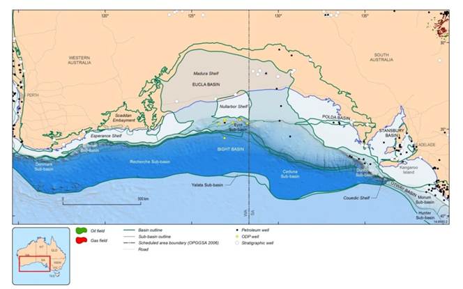
Source: Geoscience Australia, Submission 70, p. 8
1.23
Ten petroleum exploration wells have been drilled in the eastern Bight
Basin with only five in the Ceduna Sub-basin. With the exception of Gnarlyknots
1A, all exploration wells were drilled in the relatively shallow water near the
basin margin.[15]
1.24
In 2003, a Woodside Energy-led joint venture was awarded permits in the
Ceduna Sub-basin with an indicative investment of $90 million over six years. The
Gnarlyknots 1A well was drilled by the Woodside Energy-led joint venture,
however due to harsh ocean conditions it was plugged and abandoned at 4736m,
before reaching its prime objective. The failure of this venture had a
significant impact on the perception of the prospectivity of the area.[16]
1.25
As a result of the failure of Gnarlyknots 1A, Geoscience Australia
undertook a $6.7 million precompetitive study in 2007 which collected and
identified world-class marine, oil-prone potential source rocks in the Bight
Basin. As a result, there was a renewed interest in exploration in the area
with permits awarded to: BP Exploration (Alpha) in 2011 with Statoil
subsequently taking a 30 per cent interest in these permits in 2013; and
Chevron Australia New Ventures Pty Ltd, and Murphy Australia Pty Ltd and Santos
Offshore Pty Ltd in 2013.[17]
1.26
The BP permits were awarded with an indicative guaranteed work program
of $605 million and included four wells, and a secondary work program in excess
of $800 million in three subsequent years.[18]
1.27
Chevron's two permits were awarded with an indicative guaranteed work
program of $486 million including four wells, and a secondary work program of
$10 million in three subsequent years. Murphy Australia Oil and Santos
Offshore's permit was awarded with an indicative guaranteed work program of $50
million, and a secondary work program of $53 million in three subsequent years.
The guaranteed work programs for the three permits is valued at $536 million
over the first three years.[19]
1.28
Since the award of permits in 2011, exploration activities conducted by
permit holders has resulted in the acquisition of approximately 32,000km2 of
3D seismic surveys. The data acquired from these surveys has transformed the
knowledge base for the Basin by providing uniform coverage in high quality 3D
data.[20]
1.29
The Department of Industry, Innovation and Science noted that
titleholders are currently undertaking geological studies and planning four
exploration wells due to be drilled by October 2018.[21]
Overview of the Great Australian Bight
1.30
The Great Australian Bight extends from Cape Catastrophe, Eyre Peninsula
in South Australia to Cape Pasley, east of Esperance in Western Australia. This
coast is part of the world's longest south-facing continental margin. It
experiences small tidal heights but is exposed to the strong wind and wave
regimes generated in the Southern Ocean. Intense low-pressure systems that
traverse the Southern Ocean occasionally hit the coast.[22]
1.31
For over 200 kilometres from the Head of the Bight in South Australia to
the Western Australian border, iconic limestone cliffs averaging 80 metres in
height rise above the water. These coastal cliffs are of both geomorphological
significance, and are considered of high scenic value.[23]
1.32
Isolation and difficult coastal access combine to make the Great Australian
Bight relatively pristine. It is a region with high levels of biodiversity and
endemism, and is recognised as being of global conservation significance for
species of rare and endangered marine mammals and seabirds. It provides
critically important calving regions for the endangered southern right whale,
and colonies (including pupping areas) for Australia's only endemic pinniped,
the Australian sea-lion. Other protected species known to inhabit the area
include the great white shark, humpback whale, and a number of species of
albatross.[24]
1.33
Mr Matthew Collis, Policy and Campaigns Manager for the International
Fund for Animal Welfare (IFAW) stated that:
The bight is an incredibly important area for marine mammals.
It is home to nearly half of all the world's species of whales and dolphins,
and all three species of seals and sea lions found regularly in mainland
Australian waters. The Australian government has mapped biologically important
areas in the bight for blue whales, southern right whales, sperm whales and the
Australian sea lion, some of which overlap directly with, or are in close
proximity to, BP's proposed drilling area. The bight is also recognised as
globally important for elusive and rarely seen beaked whales.[25]
Coastal environment
1.34
The coastal environment of the Great Australian Bight includes a number
of areas of outstanding natural value. These include the Head of the Bight,
Nuyts Archipelago, Kangaroo Island, Recherche Archipelago, and the Coorong
Coast.
1.35
The Head of the Bight, marked by its shallow waters, provides critically
important habitat for calving southern right whales, and sharks and seals.[26]
1.36
Nuyts Archipelago contains a complex of highly varied marine habitats
which provide important nursery and feeding grounds for commercially and
recreationally important crustacean and fish species. The southern right whale,
Australian sea-lion, New Zealand fur seal, and a variety of bird species
including little penguins also use the area for feeding and breeding. Kangaroo
Island similarly supports populations of little penguins, and significant
populations of Australian sea-lions and New Zealand fur seals. It also supports
populations of coastal wading birds, and white-bellied sea eagles.[27]
1.37
The Recherche Archipelago is composed of over 1500 granite islets with
headlands and sandy beaches. It supports seagrass meadows and a variety of
reefs. It provides habitat to over one per cent of the world's population of
short-tailed shearwaters, white-faced petrels and pied oystercatchers. The
Archipelago also provides habitat to a significant population of little
penguins. Further, it is the only breeding site for the western subspecies of
the Cape Barren goose, and supports a number of breeding colonies of Australian
sea-lions and New Zealand fur seals.[28]
The waters of the Eastern Recherche also provide important seasonal calving
habitat for the southern right whale, important foraging areas for the great white
shark, Australian sea-lion and the migratory flesh-footed shearwater.[29]
1.38
The Coorong Coast contains the Coorong National Park which was declared
to protect the shallow saltwater lagoons located behind the coastal sand dunes.
These wetlands are of national and international significance. However, the
sandy beaches and fore dunes also provide important roosting and nesting sites
for a number of bird species including the hooded plover. They also provide a
number of breeding and haul-out sites for Australian sea-lions and New Zealand
fur seals.[30]
Great Australian Bight Commonwealth Marine Reserve
1.39
Marine reserves are established to protect and maintain an area's
biodiversity, including endangered and threatened species such as whales and
pinnipeds, and their habitats. Marine reserves are globally recognised as one
of the most effective ways to maintain the long-term health and productivity of
marine ecosystems.
1.40
Commonwealth Marine Reserves (CMRs) are established by proclamation
under the Environment Protection and Biodiversity Conservation Act 1999
(EPBC Act). The Director of National Parks is the statutory authority
responsible for the administration, management and control of Commonwealth
reserves under the EPBC Act.[31]
1.41
Management plans for CMRs are required under the EPBC Act and these
plans give effect to broad reserve management principles, define what activities
may occur within the reserve, and the level of approval required for each
activity. The content of management plans is prescribed in the EPBC Act[32]
and must detail how each zone of a reserve is to be managed, and include the
conditions under which mining operations may be permitted in the reserve.
Management plans must be approved by the Minister and registered on the Federal
Register of Legislative Instruments.[33]
1.42
The Australian Government adopted the International Union of
Conservation of Nature (IUCN) protected area categories for defining the
management principles for CMRs. These categories have been given legal effect
under section 346 of the EPBC Act and schedule 8 of the EPBC Regulations. Each
CMR is assigned an IUCN category at proclamation, though a CMR may also be
divided into two or more zones with an IUCN category applied to each zone.[34]
Great Australian Bight Marine Park
1.43
In 1998, the Great Australian Bight Marine Park (Commonwealth Waters)
was declared by proclamation. In November 2012, the Great Australian Bight
Commonwealth Marine Reserve (GAB CMR) was declared as part of the South-West
Commonwealth Marine Reserve Network. The reserve was reproclaimed in 2013 to
allow for the independent review of marine reserves announced by the Australian
Government in 2012. While the review is under consideration, transitional
arrangements for all reserves were declared by the Director of National Parks.[35]
1.44
The GAB CMR covers an area of more than 45,00km2. It
encompasses the former Great Australian Bight Marine Park (Commonwealth Waters)
which stretched 200km west of Ceduna in South Australia following the coast to
the Western Australian border. It includes a 20 nautical mile wide strip
extending to 200 nautical miles offshore.[36]
1.45
The area of the former Great Australian Bight Marine Park (Commonwealth
Waters) comprised two overlapping zones—the Marine Mammal Protection Zone and
the Benthic Protection Zone. The Mammal Protection Zone was intended primarily
to provide for undisturbed calving of the southern right whale and protection
of Australian sea-lion colonies. The Benthic Protection Zone was intended to
protect a sample of the unique and diverse plants and animals that live on and
are associated with the ocean floor of the Great Australian Bight.[37]
1.46
The major conservation values for the area include:
-
globally important seasonal calving habitat for the threatened
southern right whale;
-
important foraging areas for the:
-
threatened Australian sea-lion,
-
threatened white shark,
-
migratory sperm whales, and
-
migratory short-tailed shearwater;
-
examples of the western ecosystems of the Great Australian Bight
Shelf Transition and the easternmost ecosystems of the Southern Province; and
-
three key ecological features including the ancient coastline,
the benthic invertebrate communities of the eastern Great Australian Bight, and
areas important for small pelagic fish.[38]
1.47
Under the transitional management arrangements for the GAB CMR, the
management of the former Great Australian Bight Marine Park (Commonwealth
Waters) must be consistent with the arrangements in place prior to November
2012. Under these previous management arrangements, mining (including
exploration) was allowable in the Benthic Protection Zone but not allowed in
the Marine Mammal Protection Zone. Under the GAB CMR, oil and gas exploration
and mining is allowable in the Multiple Use and Special Purpose Zones (IUCN VI
zones) of the reserve, but are not allowed in the Marine National Park Zone
(IUCN II).[39]
1.48
The Director of National Parks also issued a general approval under
section 359B of the EPBC Act for the areas of the GAB CMR which were not
included in the former Great Australian Bight Marine Park (Commonwealth
Waters). This removes the need for any further approval of individual
activities to be sought from the Director of National Parks.[40]
1.49
The Great Australian Bight also contains a number of other marine
reserves as illustrated in Figure 1.2 below.
Figure 1.2 – Marine reserves in the Great Australian Bight
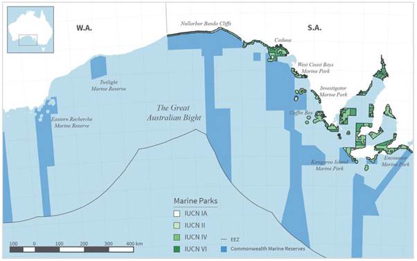
Source: Mr Laurent
Lebreton, Submission 35, Attachment 1, p. 18.
Great Australian Bight marine environment
1.50
Geoscience Australia provided the committee with a summary of information
on the marine environment of the Great Australian Bight. The summary included
that the seabed within the Bight comprises a broad continental shelf and continental
slope that descends to 4,500 m water depth. Submarine canyons have incised
deeply into the continental slope within the Great Australian Bight with shallower
canyons known to provide habitat for rich communities of biota. Canyons also
influence local productivity of the Great Australian Bight by acting as
pathways for localised upwelling of nutrient-rich waters.[41]
Marine mammals
1.51
For the Great Australian Bight, and more specifically the area that may
be affected by BP's proposed drilling, there are 28 whale species, eight
dolphin species and three pinniped species listed under the EPBC Act. Of
the whale species, five are listed as threatened.[42]
1.52
Within the Great Australian Bight, a number of Biologically Important
Areas (BIAs) have been recognised for marine mammal species. Mr Collis stated
that:
The Australian government have highlighted, through the
collection and review of research that exists, what they call 'biologically
important areas' for marine mammals in the Great Australian Bight that includes
blue whales, southern right whales, sperm whales and the Australian sea lion.
There is well documented evidence of where those important areas are for those
animals and they do, by in large, crossover with some of the exploration leases
or within close enough proximity to certainly be affected by any spill.[43]
1.53
The southern right whale BIA is located approximately 220 kilometres
from BP's proposed drilling sites. Typically, the southern right whale is
present off the coast of southwest Western Australia and the far west of South
Australia between May and November. As previously mentioned, the Head of the
Bight is a significant aggregation area for southern right whales with up to
half of the population gathering between May and November to calve.[44]
1.54
It is known that there are significant southern right whale migratory
pathways through the Great Australian Bight, however exact pathways are
currently unknown. It is thought that between September and November,
populations move offshore to feeding areas including the Antarctic ice edge. It
is also believed that the entire coastline from Kangaroo Island west to the
Perth Canyon is an important migratory pathway and that there is likely to be a
seasonal westward movement. Southern right whales have also been observed
migrating directly into the Head of the Bight from a southerly direction, and have
been observed moving out of the bight in a southerly direction without
following the coastline.[45]
1.55
The Antarctic blue whale and the pygmy blue whale are both known to have
feeding grounds in the Great Australian Bight. Both species feed on krill with Antarctic
blue whales feeding primarily during summer and autumn, and pygmy blue whales
feeding during November to May. Pygmy blue whale migration is thought to follow
the continental shelf break, and a migration BIA is located approximately eight
kilometres from proposed drilling sites.[46]
The endangered blue whale is found particularly around the Bonney upwelling
area between Ceduna and Portland where upwelled nutrients stimulate the bloom
of phytoplankton which provides an abundance of food.[47]
1.56
Important foraging grounds for sperm whales are also located along the
shelf break of the Great Australian Bight, and in waters south of Kangaroo
Island. This BIA overlaps with the northern 15 km of BP's proposed drilling
area.[48]
The International Fund for Animal Welfare (IFAW) submitted that it undertook
the first-ever boat-based acoustic survey for cetaceans in the eastern Great
Australian Bight. This study found sperm whale densities in the Kangaroo Island
Canyons equivalent to other 'global hotspots' for sperm whales. The study also
sighted six rare Shepherd's beaked whales, which have only been seen alive at
sea on fewer than 10 occasions globally. IFAW submitted that based on a review
of unpublished data on live sightings and strandings, it is believed that the
Great Australian Bight provides important habitat for deep-diving species of
cetaceans such as beaked whale species and pilot whales.[49]
1.57
The Australian sea-lion is listed as vulnerable under the EPBC Act, and
as a threatened species under state legislation in both South Australia and
Western Australia, is known to only breed in the coastal and offshore waters of
South Australia. The estimated pup production per season is approximately 2,432
with estimated population estimates between 9,900 and 14, 700 over a number of
decades.[50]
Reptiles and birds
1.58
In the Great Australian Bight, all three species of marine turtle found
in the area are listed under the EPBC Act as threatened and migratory. These
include loggerhead, green, and leatherback turtle species.[51]
1.59
In addition, 19 species of bird are listed under the EPBC Act as
potentially being found in the proposed drilling area. These include migratory
species which migrate annually to and from feeding and breeding areas. There
are also a number of foraging BIAs in the Great Australian Bight which exist
for listed species such as the antipodean albatross, the flesh-footed
shearwater, the little penguin, and the great-winged petrel.[52]
Benthic invertebrates
1.60
Geoscience Australia commented that the Great Australian Bight supports
one of the world's most diverse soft-sediment ecosystems and has a high level
of endemism, meaning many species occur nowhere else in the world. An estimated
85 per cent of fish, 95 per cent of molluscs, and 90 per cent of
echinoderms are endemic to southern Australia. The Great Australian Bight has
one of the world's highest species richness of macroalgae, with over 1,200
species and 75 per cent of red algae species endemic to southern Australia.[53]
1.61
Geoscience Australia went on to note that much of the information about
biodiversity in the Great Australian Bight is for the continental shelf, with
little known about biodiversity along the deeper waters of the continental
slope.[54]
Regional population and industry profile
1.62
Whyalla and the Eyre Peninsula is one of the most complex planning
regions in Australia. It is remote, vast in size at 230,000 km2 and
has a small population of approximately 57,000 people with the majority
residing in the regional cities of Whyalla and Port Lincoln.[55]
1.63
The regional economy is diverse, with key industries including
agriculture, manufacturing, fishing, and aquaculture. Tourism and mining are
the region's fastest growing industries with substantial potential for future
growth. Though industrial diversity provides strength and resilience, it is not
shared across the region with particular industries focused in individual towns
and areas. For example, 76 per cent of the region's fishing jobs are based in
Port Lincoln, and tourism activity is predominantly focussed in coastal areas.[56]
1.64
The region has an ageing population with an older workforce profile for
most industries than both South Australia, and Australia. There is an expected
surge in retirements which has the potential to reduce the region's labour
force by approximately 40 per cent by 2020. Additionally, the region has a
smaller proportion of young people to replace these retirees, and an annual exodus
with 30 per cent of the region's young people moving to Adelaide
for employment and study.[57]
Industry and tourism
1.65
The Great Australian Bight supports a number of industries including
commercial fisheries and eco-tourism. Significant commercial fisheries include
oyster, abalone, blue crab, marine scalefish, pipi, prawn, rock lobster, and
sardine. Of all the wild-catch fisheries, the rock lobster is estimated to be the
most valuable, followed by prawn and abalone.[58]
The region contains five Commonwealth fisheries managed under the Fisheries
Management Act 1991 (Cth), and six South Australian fisheries managed under
the Fisheries Act 1982 (SA). It also supports significant recreational
fishing, and fishing based tourism.[59]
1.66
South Australia's fishing and aquaculture production in 2010–11 was
valued at $425.5 million, with the Great Australian Bight region accounting for
97 per cent of production valued at $234.7 million. The region accounted for
100 per cent of South Australia's southern bluefin tuna production, 100 per
cent of marine finfish production, 97 per cent of oyster production,
92 per cent of mussel production, 62 per cent of abalone production,
and 97 per cent of all other aquaculture. It also supports an important sardine
fishery with 94 per cent of the catch sold as tuna farm fodder.[60]
1.67
The southern blue fin tuna industry is Australia's most profitable commercial
aquaculture industry. The South Australian Government submitted that it
contributes $136 million annually to State Gross Product (SGP).[61]
1.68
The South Australian oyster industry directly employs 254 full-time
equivalent (FTE) in regional areas, supports a further 433 FTE in downstream
positions, and contributes to a further 533 FTE in flow-on business activity.[62]
According to the South Australian Oyster Growers Association (SAOGA), the
industry contributes $35.3 million in farm-gate value to the state's economy
and a further $68.3 million from associated downstream activities. In
addition, the oyster industry contributes $145.6 million to the economy through
flow-on to other sectors.[63]
1.69
Tourism is also a major contributor to the economy in the region providing
a combined $1.2 billion per year for 2013–2014. Employment from the tourism
industry in the region containing marine parks is estimated to directly and
indirectly account for nearly 10,000 full-time equivalent jobs.[64]
The Eyre Peninsula was the fourth most popular tourism region in South
Australia with an estimated 390,000 visitors in 2012. Visitor expenditure
exceeded $277 million in 2011–12, from 700 businesses.[65]
1.70
The Aboriginal Lands Trust owns and manages the Head of the Bight
Visitor/Interpretive Centre which it stated 'is a successful Aboriginal
business and is situated on Aboriginal freehold held by the Aboriginal Lands
Trust'. It stated that the Head of the Bight:
...is recognised as one of South Australia's iconic tourist
destinations with a growing profile both nationally and internationally. The
area promotes the local habits and biodiversity as well as the behaviours and
other scientific curiosities relating to the Southern Right Whale.[66]
1.71
The Aboriginal Lands Trust also stated that during the whale season, on
average approximately 30,000 tourists visit the Centre each year between mid-May
and late October. It noted that:
The cost to manage and maintain the Centre is dependent upon
visitor attendance and ticket sales which enables the Trust to offer a great
facility for up close experiences with the Southern Right Whales and other
marine life. It is a major tourism draw card for the region.[67]
1.72
The creation of highly protected marine ecosystems is expected to
further provide a strong base for developing ecotourism in South Australia in
the longer term by supporting the growth of activities such as whale and
dolphin watching, shark watching, scuba diving and boating.[68]
The City of Victor Harbor highlighted that the opportunity to 'view whales up
close and in their natural environment' has become a 'marketable experience'.
It particularly noted that 'day trippers for whale watching during the quieter
winter months provides some economic stimulus that may not otherwise exist'.[69]
Current research and scientific knowledge
1.73
Scientific research is crucial to understanding the potential
environmental, social and economic impacts of offshore oil and gas activity in
the Great Australian Bight. NOPSEMA stated that 'it is of fundamental
importance that the impact and risk evaluation process be supported by current
knowledge and scientific evidence, relevant to the proposed activity, its
timing, duration and location'.[70]
1.74
The Australian Marine Conservation Society (AMCS) submitted that despite
a general understanding of the Great Australian Bight, it remains a largely
unexplored frontier. Further, despite universal agreement amongst the
scientific and conservation community as to the Great Australian Bight's
significance, there are a number of knowledge gaps including of the region's
physical processes, biodiversity and ecology. The AMCS submitted that:
Senior scientists and researchers have authored a review of
science knowledge of the Bight and have identified a range of key knowledge
gaps in our current understanding of the region’s physical processes,
biodiversity and ecology. This major science review has made it clear that we
cannot confidently assess the implications of potential oil spills for the
region’s ecosystems and reliant industries. This review noted that "Our
current knowledge of the [Great Australian Bight] is not sufficiently developed
to confidently assess the implications of potential oil and gas production,
including potential oil spills, for the region’s diverse marine ecosystems or
for its economically important existing marine industries".[71]
1.75
The committee also received evidence that there are significant
knowledge gaps in understanding the behaviour of migratory cetaceans. IFAW
noted that oil and gas proponents have collected data, but that this
information has not been widely shared. IFAW stated that:
Scientific knowledge on marine life in the GAB, including
most cetacean species remains poor. There is relatively little peer-reviewed
published material and it is limited to just a few species. More data exists,
with some collected by scientific studies and other data collected to inform
environmental impact assessments by oil and gas companies. While it is welcome
that such research was funded, it is deeply regrettable that the data is not
shared more widely by companies or funding not provided to researchers to
enable them to write up and publish this data.[72]
1.76
Mr Matthew Collis, IFAW told the committee that 'our scientific
knowledge of the bight is still relatively limited, particularly for species
that spend most of their time offshore. This underlines the need for better
baseline data before allowing damaging activities to proceed'.[73]
1.77
Similarly, the Humane Society International (HSI) submitted that 'for
many of the threatened species found in the Great Australian Bight, there is
still little scientific research to be able to identify critical habitat'. HSI
concluded that as a result of these gaps in knowledge:
...the impacts of oil or gas development in the area are likely
to be more severe than current scientific knowledge suggests, with significant
implications when considering exploration or drilling activities or should an
oil spill occur.[74]
1.78
The committee received evidence of a range of research projects which
are currently being undertaken by the scientific community in conjunction with
state and commonwealth governments, and industry stakeholders. In particular,
the Great Australian Bight Research Program, which involves BP, CSIRO, the
South Australian Research and Development Institute (SARDI), the University of
Adelaide and Flinders University. BP submitted that:
This A$20 million four-year programme is one of the largest
whole-of-ecosystem research programmes ever undertaken in Australian waters. It
will obtain information to improve understanding of the environmental,
economic, and social values of the Bight to inform future sustainable
development. The programme will focus on seven major research themes including
oceanography, pelagic (open water) ecosystem and environmental drivers, benthic
(ocean floor) biodiversity, iconic species and apex predators, socio-economics
and ecosystem modelling.[75]
1.79
The Wilderness Society stated that the Great Australian Bight Program is
'intended to produce an Integrated Ecosystem Model of the Bight – a powerful
state-of-the art modelling tool of the structure and dynamics of the region’s
ecosystems'. But it also noted that the key outputs of this project are not
expected to be available until mid-2017, which would have been after the
scheduled first exploratory drilling proposed by BP.[76]
1.80
Ms Claire Charlton from Curtin University told the committee that
research for the Great Australian Bight Whale Project is conducted in
collaboration with a range of organisations including universities, state
government organisations such as the South Australian Museum and Western
Australian Museum. Ms Charlton noted that:
Current sponsors of this project are Murphy and Santos, who
are oil and gas permit leaseholders here in the Great Australian Bight. Murphy
and Santos are completing a three-year sponsorship of a PhD program as well as
providing funds to see the long-term project continue. It is important to note
that they recognise the importance of having a robust baseline dataset and
information on the existing environment to be able to inform risk based decision
making into the future.[77]
1.81
Ms Charlton explained that the objectives of the research are aligned
with the Commonwealth Conservation Management Plan for the Southern Right Whale
and includes:
...monitoring from the Head of Bight, from the Bunda Cliffs,
and we complete population census, photo ID, fine-scale behaviour, underwater
acoustics and just this year we have started collaborating with Murdoch
University to use drones to assess the health and the body condition of the
whales.[78]
1.82
APPEA submitted that in addition to these studies, there are a number of
other programs being undertaken in collaboration with oil and gas companies.
These include the CSIRO Great Australian Bight Deepwater Marine Program—a
collaborative project with Chevron; and the Curtin University—Great Australian
Bight, Understanding Underwater Sound Impacts—a collaborative project with BP.[79]
1.83
APPEA noted that scientific knowledge is advanced by information
obtained directly from industry exploration activities including seismic
surveying and drilling. It submitted that this knowledge is shared with the
scientific community to build a broader knowledge base of the Great Australian
Bight, and to ensure that all operations are conducted with minimal impact on
the marine environment.[80]
1.84
Some submitters such as the Clean Bight Alliance Australia (CBAA) expressed
concern regarding the independence of research conducted by or funded by the
oil and gas industry. The CBAA stated that:
Furthermore any research conducted or funded by companies
should be thoroughly scrutinised and peer reviewed otherwise it cannot be seen
as independent or reliable. CBAA believe that increasing our scientific
knowledge of the GAB is a highly valuable task which should not be reliant on
corporate funding.[81]
1.85
However, others such as IFAW stated that it 'has no problem per se with
industry funding research, in fact we would welcome more funding, but the
topics and priorities for research should be decided by scientists
independently of funders, rather than research that suits the agenda or whim of
a particular company'.[82]
Navigation: Previous Page | Contents | Next Page